Monday, 23 October 2023

Battle of Hastings - Where did William land in the Port of Hastings?


 Where did William land at Hastings?

In this post I'd like to discuss where William landed at the port of Hastings. This is not about the knights leaving Hastings on the night prior to the battle but rather about where the foot of the Norman invader touched English mainland soil. To start, I'm going to use a page out of Hastings Historic Character Assessment Report April 2010. 

https://www.westsussex.gov.uk/media/1728/hastings_eus_report_maps.pdf

The above irl refers to a map of the underlying geology of Hastings Town centre. You will notice the extensive deposits of alluvium on what is now dry land ( alluvium is deposited by rivers?). At one point in time there must have been a large river emptying into the sea here thus making a good harbour.

Key: Green = land, Orange = water in the time of 1066, Blue = present day sea extent. 

Here's what I think the inlet would have looked like back in 1066. 

Now, the default wind direction is from the South west so any captain would have sought out a landing place on the western shore of an inlet subject to terrain. Also William had to move men and material from the shore inland to conquer it(!). 

We have no written accounts of where exactly William landed so all we have to go on is speculation. 

The present narrative calls for William to build a fort at Hastings which is remodelled in stone at a later date. So, the stone castle on the West Hill is thought to be the site of an early wooden fort built at the time of conquest. However, there is a problem with this thought. As any resident of Hastings knows, the land between say the present railway viaduct and Hastings Castle consists of a narrow strip of flat land backed by a very steep slope to the top of the ridge that ends with the castle.  I would imagine in geological terms that the river that flowed out here washed away the eastern bank.  Another thing to take account is the river bed when it went past the entrance to the inlet. 

                                           
                                              America Ground                                      Castle


Although this shows the modern ground level it echos what would have been the channel back in 1066. That is, the deepest part of the channel would have been closer to the castle. So in my opinion the castle was built there to protect the harbour from any seabourne invasion.

My theory is that William first touched English mainland soil in the vicinity of where Hastings Priory was built. Firstly, it is on the western edge of the inlet thus protected from the dominant wind. Secondly, it has the shortest route to the ridge behind Hastings without any undo elevation climbs. And thirdly, a Priory was built as a sort of "blue plaque" in honour of William and authorised between 1189 and 1199 ( reign of Richard the Lionheart). 


Sunday, 22 October 2023

Battle of Hastings - Cross section of the Main Battle Area


Cross Section of the Main Battle Area

In my last post I showed where I thought the main battle took place in 3D and what it looks like today courtesy of Google Earth. Today I bring you a cross section of the area to show Harold's battle planning. 

At zero on the "x axis"  is Wadhurst Lane where according to Wace the accompanying clergy of the Norman Army decanted to in order to watch the battle and pray. Looking at the slope now I think they might have been a little closer to the battle at the 80 metre mark say in order to see the debacle at the prepared defences. It is interesting to note that English Heritage when questioned about Wace's comment referred me to that Wace is describing a battle that happened in 1105 at Tinchebray but offered no supporting evidence.

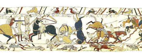
I would also draw your attention to the fact that the Normans would have charged downhill towards the English line. I don't know if you have tried running downhill with abandon but it usually ends in a loss of control and crashing into something! In this case the Norman knights met with the defensive ditch as per Scene 53 of the Bayeux Tapestry


By Image on web site of Ulrich Harsh. - http://www.hs-augsburg.de/~harsch/Chronologia/Lspost11/Bayeux/bay_tama.html, Public Domain, https://commons.wikimedia.org/w/index.php?curid=17142223

The bottom of the slope is reached at approx 230 metres from Wadhurst Lane in what looks like a shallow ditch. Wace records in his work, Roman de Rou, that the English had made a ditch which ran through the fields. Now, it takes time to prepare defences like this. So, the earlier encounter the Normans had with the Huscarls must have been an attempt to slow down the invaders in order to give Harold's less able troops time to get things in place. Henry of Huntingdon has the Normans falling into a "deep trench" unawares due to the trenches being covered. In my reading of other modern reports on where folk think the battle happened, none have shown this ditch.

The ground now rises from the 260 metre mark to 320 metres from Wadhurst Lane.  How close the English were to the ditches is unknown but Harold, I would assume, would be at the peak of the ridge. This could explain why there is confusion over the "arrow in the eye" incident. The Norman archers could not closer than the 260 mark and thus Harold being higher in elevation and 60 metres away would be outside the killing range of a bow and arrow. It is interesting to note that the Bayeux Tapestry  show two members of the Fyrd exiting stage right with arrows in their eyes. 

Btw, I'm an electronics technician by training. This means I was trained to take on board all symptoms when trying to diagnose faults on a complex system, not just those which fit one's pre-determined idea. I've applied the same approach in trying to find the true battle site of Hastings. 


Battle of Hastings - The small battlefield?


My Chosen Battle Site for 14th Oct 1066
 
This site lies to the north west of Battle and as stated on the picture this represents the area where the main battle and Malfosse took place. 

The purple line represents where, according to Wace, the observing clergy stood praying and watching the battle. This also happens to be part of Wadhurst Lane, a restricted byway ( not for use for mechanically driven vehicles), which runs in part from the B2096 and Netherfield Road. It is high ground (109m - 111m) overlooking the the lowest levels of the English line. 

The turquoise ring represents where the English formed up to receive the Norman charge. The remaining portion of the English Army was here. Both the Carmen and Henry of Huntingdon indicate that the English were closely packed in their defensive line By my estimation there were 4500 English facing at least a comparable number of of Normans. Imo, this is what part of Scene 53  and Scene 54 of the Bayeux Tapestry attempts to show. 

  https://en.wikipedia.org/wiki/Bayeux_Tapestry_tituli#/media/File:BayeuxTapestryScene53.jpg
( From the drooping branch right)

https://en.wikipedia.org/wiki/Bayeux_Tapestry_tituli#/media/File:BayeuxTapestryScene54.jpg
( From the left to where the "mound" finishes)

All along the southeast facing part of the English line ( the part of the line that abuts the farmland) runs a shallow ditch. This could be the remnants of the ditches written about by Wace and Henry of Huntingdon. 

So Harold could possibly have died at the highest point on this ridge beside his Standard. 

Finally, the Malfosse could be where I've drawn an orange line. This represents a natural cleft near the battlefield as written about by the monks of Battle Abbey. Also the terrain within the wood from the battleline to the Malfosse conforms to the monks description of it. 

Anyway, what do you think?

Tuesday, 11 April 2023

Battle of Hastings - The Departure from Dives

Battle of Hastings - The Departure from Dives  


Some Fundamentals

1. The ships that William used were in some way related to the ships of the Vikings. This means that the ships  - 

        a)  had shallow draft,

        b)  had removeable benches for the rowers,

        c)  if carrying horses these benches were removed, 

        d) if carrying horses the only means of propulsion was the wind. 

        e)  carrying materiel had two means of propulsion ( oar and/or sail) or not. 

        f) could sail up to 12 points off the wind (so if the wind was a straight northerly, the ships could point at 13 degrees and still make forward progress). 

2. Over the years, I believe,  the Normans had lost some of the seafaring ability of their forefathers. 


What the sources say - if anything

Will of Poitiers says that they waited for a southerly wind. After a while this turned into a westerly wind which blew them to St Valery sur Somme. 

Will of Jumièges doesn't acknowledge leaving Dives only assembling at St Valery sur Somme. 

The Carmen is a bit more expansive but equally opaque. it reckons that the way was barred by constant rain and storms and thus the fleet sheltered at St Valery sur Somme. More bad weather was experienced and there was a pulse of warmth just before Michaelmas at which point the fleet made ready to depart for England.  

Deductions?

I think the initial delay at Dives was caused by onshore breezes rather than actual Northerlies. So a typical day might consist of a warm sunny day in which the wind in the morning was slack but by afternoon was streaming from the north as Dives was a north facing port. As the ships carrying horses had no means of propulsion other than wind the Normans were stymied and had to wait for a proper wind to propel them out of the River Dives. 

A consequence of waiting for a southerly would be the arrival of a storm shortly afterward. This would mean that the wind would veer into the westerly half of the compass as the Low pressure system centre passed to the north of the fleet. The coast of France in this area turns from north between Dives and Fecamp to south west to north east between Fecamp and St Valery sur Somme. 

The upshot of a strong westerly wind would be to drive the fleet into various harbours and ports along the coast between Fecamp and St Valery. So, in my opinion, the three weeks being "stuck" in St Valery would have been used to re-assemble the fleet at St Valery before continuing to England.  I would imagine that there would not be excessive loss of life and the claim made by Nick Austin  that the Normans lost a ship carrying  a "flat pack" fort to England ( two flat pack forts instead of three) hard to understand. 


Thursday, 10 November 2022

Battle of Hastings :- Rehabilitation of "The Chronicle of Battle Abbey"

 Rehabilitation of "The Chronicle of Battle Abbey"

From my reading of John Grehan's book "1066 - An Uncomfortable Truth" I developed an antipathy for the Chronicle and being exposed to Nick Austin's work just made it worse. However, since I've obtained a translation of it, my distrust has lessened to the point where I shall spend some time to try to weave it into the fabric of the timeline of that fateful day. 

As with all 12th cent. sources things have been mis-remembered, forgotten and twisted. The Chronicle makes no mention of any skirmish but starts off with the main battle and closes with the Malfosse incident. But the Chronicle only makes sense to me if there was a skirmish. 

Description of Sites

Let's look at the location of Battle Abbey. 

It stands on top of a ridge that dominates the landscape and no doubt could be seen for miles around although its view north would have been limited.  Some commentators cite a lack of water at Battle Abbey and yes getting water to the Abbey must have been a logistical nightmare but solved somehow. 

Now listen to what the Monks surveying the battlefield said about the site.

1. "They studied the battlefield and decided that it seemed hardly suitable for so outstanding a building"

2. "... on a hill, and so dry of soil, and quite without springs, and that for so great a construction a more likely place nearby should be substituted"

3. " they gave as their reason the lack of water"

4. Again they complained of the unsuitability of the site, this time because for some distance round the ground was heavily wooded and therefore stone fit for building could not be found."

This last sentence is crucial to our understanding as to where the battle took place. Both Battle Abbey, (the Time Team site at the mini-roundabout) and Caldbec Hill are described as being on the edge of the Andresweald whereas the battlefield is surrounded by woods. As Crowhurst is even further south, it also eliminates Nick Austin's choice of battlefield.

Now let's consider Ashes Wood. 

1. For me, the monks seem to be saying that if a splendent building was placed on the battlefield, it wouldn't stand out in the landscape. Indeed, the land slopes down from Wadhurst Lane to Ashes Wood and any building would be partially hidden. So, I consider my choice of battle site meets this criterium. 

2. Is Ashes Wood on a hill? Yes, the ground rises from the bottom of Netherfield Hill near to the junction with the A2100 to the junction of Wadhurst Lane at approx 117 metres asl and then falls away slightly to about 104 metres just before the ridge inside Ashes Wood. Again, the site meets the criterium

3. There doesn't seem to be any streams nearby. 3 out of 3. 

4. Heavily wooded. If Caldbec Hill to the south is considered to be on the edge of the forest then Ashes Wood would have been one part of a much larger forest.

So, my choice of battlefield ticks all the boxes according to the monks surveying the actual battle site. 

Is Battle Abbey in the wrong place then?

Both yes and no.

In the Chronicle we have the following "... chose a fit place ... a site located not far off, but somewhat lower down, towards the western slope of the ridge. ... This place, still called Herste, has a low wall as a mark of this".

In my opinion, if the English Heritage site was the battle location then Nick Austin's Crowhurst site comes into view as it is on the western side of the Ridge, which runs from the Station Approach in Battle to the castle on West Hill in Hastings.

However, if I'm correct then Battle Abbey's location is the compromise location. This is because it is lower down from the battlefield at Ashes Wood ( 83 metres above sea level as opposed to 104 metres for Ashes Wood) and more importantly "towards" the Ridge.i.e. closer to the Ridge than the true battlefield.

Now we have to contend with "he refused angrily and ordered them to lay the foundations of the church speedily and on the very spot where his enemy had fallen and the victory won".  This sentence is used to "prove" that Battle Abbey is in the "right" spot  but what do the monks write at the start of the next paragraph?  "...and they prudently erected the High Altar as the king commanded, on the very place where Harold's emblem, which they call a 'standard, was seen to have fallen".  So now we have a different marker in place for Harold. Not his body but Harold's Standard.

Eleanor Searle in her introduction ( page 15) highlights the fact that only saints resting places are placed under a High Altar not ones enemy. And consider the first time William's vow is recorded on page 37  "I make a vow that on this very battlefield I shall found a monastery for the salvation of all, ..." No mention of the place where Harold will fall at all. Only later do the monks record, on page 45, that the place of Harold's death had to be taken into account. I think there is a case of "mission creep" coming into play. 

However, I think the monks won the argument by saying that if sir remembers, he bested Harold's best troops in a skirmish nearby the compromise location and therefore set up his victory over Harold in the morning and thus should mark that location. 

So, there you go then. A deep dive into the text of the Chronicle reveals some excellent location details which excludes any site south of mine. 


Wednesday, 2 November 2022

Battle of Hastings - An Additional Criterion?


Battle of Hastings - An Additional Criterion?

From Wace's Roman de Rou we learn that the clergy separated from the troops by going to the top of a nearby hill in order to pray to God and observe the Battle. This is the first time I've seen this and to me it seems to be a very important restriction on the site of the Battle. 

To me, it explains why the Bayeux Tapestry gives so much detail  of the battle  - someone was keeping tabs on the fighting. I also feel more confident about splitting up those last 8 scenes ( 51 through 58) into 4 x 3 hour slots in order to keep "church" time. 

Although there seems to be no formal written evidence, there must have been English clergy doing the same for Harold and his army. 

Let's apply this criterion to the proposed sites for the battle

Official site                                  Distance to Clergy   approx 800 metres

Calbec Hill                                   Distance to Clergy   impossible

Mini -roundabout                         Distance to Clergy   approx 600 metres

Crowhurst                                    Distance to Clergy    approx 700 metres

Ashes Wood                                 Distance to Clergy    approx 400 metres

Beech Farm                                  Distance to Clergy   impossible

Beechdown Wood                         Distance to Clergy   impossible

3 miles east of Battle                     Battlefield lacks preciseness 

Near Netherfield                            Distance to Clergy   impossible


Only my site - Ashes Wood - fits all the criteria reasonably. Here's hoping that something is found soon. 

Thursday, 25 August 2022

Battle of Hastings - Was Harold Killed at Battle Abbey?

Battle Abbey - is it really the resting place of Harold? 

completely revised 03/12/2025

It is important to work out where Harold died as that will point up us in the direction of his last battle. Even though I first worked out the order of events then figured out where Harold died, the mainstream narrative has Harold dying on Senlac Ridge at the High Altar of the Abbey's church. I want to figure out the thought process of whoever decided that Harold died at that location. 

For me, the main reasons why Harold was thought to be on Abbey grounds are the two pieces of evidence in the Chronicle of Battle Abbey (CBA) namely 

[William speaking] I make a vow that on this very battlefield I shall found a monastery for the salvation of all" (CBA  Circa 1180 Translation by E Searle pp 36-37). 

"They [the four monks, Theobald the Old, William Coche,Robert of Boulogne and Robert Blancard] studied the battlefield and decided that it seemed hardly suitable.... "

"... church built on a hill"

"dry of soil, and quite without springs"

"when the King heard this he refused angrily"  and told them to get on with it and importantly "on the very spot where his enemy had fallen and the victory won". 

(CBA  Circa 1180 Translation by E Searle pp 42- 45).

The only reply the monks had to that was that good stone would be hard to find due to the area being heavily forested.

I hear no other supporting evidence for Harold dying on Senlac Ridge although they could use William of Malmesbury writing in his tome " Chronicle of the Kings of England" ( circa 1125)

"William built another monastery near Hastings, dedicated to St. Martin, which was also called Battle,  because there the principal church stands on the very spot, where, as they report, Harold was found in the thickest heaps of the slain"

Chronicle of the Kings of England (circa 1125) copyright free version by J.A Giles ( 1847) based on Rev John Sharpe's translation of 1815 page 300.

 So, the evidence I have produced so far points in the direction of Battle Abbey being the correct place however, and there is always a "however", there is contrary evidence from within the CBA which demolishes what has gone before. The word "won" occurs on line 5 of page 45 and line 25 on the same page starts

"And so at length, the foundations were laid of what in those days thought an outstanding building and they prudently erected the high altar as the king had commended, on the very place where Harold's emblem, which they call a 'standard' was seen to have fallen"

(CBA  Circa 1180 Translation by E Searle pp 44- 45).

It is believed that the first part of the CBA ( up to pp 66 - 67) was written in and about 1154. When this passage is brought to the attention of historians they dismiss it as being too long after the battle for it to be correct ( 1066-1154) And since William of Malmesbury was told back in 1122 ( at the latest)that Harold had died at the ridge why wait for so long to come clean? To me this is significant as Henry II was on the throne as the first Plantagenet king. Perhaps the monks felt safe from retribution for not carrying out the wishes of William the Conqueror.  My point however is why is something they agree with is right but 20 lines later something they disagree with is incorrect. Any answers in the comments below?