Wednesday, 17 July 2024

Battle of Hastings - The Narrative I Derive From the Bayeux Tapestry Part 1

The Narrative I Derive From the Bayeux Tapestry 

 Introduction

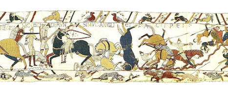
The first book I was given on the Battle of Hastings was D. M. Wilson's " The Bayeux Tapestry". It's a book that shows the Bayeux Tapestry on a 1:1 scale so it's very good at showing what is actually depicted on the Tapestry rather than what you are told it depicts. However, for the purposes of this article I will be using public domain images ( from Images on web site of Ulrich Harsh. - http://www.hs-augsburg.de/~harsch/Chronologia/Lspost11/Bayeux/bay_tama.html via Wikipedia_ tituli) of the Tapestry to illustrate my argument. 

The Tapestry sits in a weird place in the scheme of things. It is not allowed to sit wholly in the Art scene as there seems to be only one interpretation allowed of it. But the Tapestry is also mistrusted as a source of historical record. A classic case of 'Heads you lose, tails I win'.

The Bayeux Tapestry


This embroidery, to give its proper English name, is reputed to have been made in the south of England prior to 1080 which makes it one of the earliest records of the events surrounding the battle and of the battle itself. If it was true that it was commissioned in England, then this makes it the most complete account from the English side. The Anglo-Saxon Chronicles written at that time by monks seem to be more concerned with local matters with a smattering of “national” news. The modern-day equivalent would be a bulletin of local radio news about the events in a small English town with a ten second clip at the end of the news saying something of national importance.


The purpose of the Bayeux Tapestry, in my opinion, was to enlighten the lower classes of the people of Normandy as to how their leaders had conquered the English.


My study of the Tapestry started at Scene 40 and went through to the end (Scene 58). However, I centred my attention on just to the left of centre on Scene 48 to the end of the Tapestry.


The Bayeux Tapestry is not without its errors or possible additions.


                                                                   Sketch 1


A comparison of the same tower from Scene 46 one with a cupula as depicted on the Tapestry and one without. Notice how the “tower” now looks like a gable end of a building with a pitched roof. The stitching is done in the same coloured wool for both the cupula and pitched roof suggesting the stitching was done at the same time, the same coloured stitching extends into the lettering on the tapestry to the top right of the object. The same coloured stitching stops at the letter “W” in Willeim which suggests to me that the Tapestry was “improved” and restored (pitched roof added) at a later date.

My Interpretation of the Bayeux Tapestry

My interpretation of the Bayeux Tapestry starts on Scene 48 where it is thought that picture shows the Norman knights setting off to meet the English.  It ends on Scene 58 with the Fyrd running away from the battle scene.

Scene 48 to Scene 49


Scene 48


Scene 49 

This shows the Norman knights traversing fairly flat terrain finishing with a knight pointing, with raised arm, to the English.

There are two things to note. One the writing above the figure believed to be William in Scene 48 refers to the knights coming from Hastings (Here the knights have left Hastings and have come to the battle against King Harold) but the sketch shows William with his equerry. To me this means that William was in a different place than his knights, bolstering Kathleen Tyson’s claim that William was at the manor belonging to Fécamp Abbey the evening before the battle.  Secondly, notice that the terrain that the Normans cross is relatively flat before a final hurrah to get to Telham Hill. This does not match the terrain between the coastal fort and the location of the muster point.


If the terrain is mapped out between Guestling and Telham Hill then the results that one gets is a path that fluctuates between 19 and 50 metres before rising to 130 metres at the muster point -just like the Tapestry is showing.

 Frame “Lauds ” (Dawn or about 07:00)

 This includes part of Scene 49 and Scene 50.


Scene 49

Scene 50

This frame runs from Scene 49 to Scene 50 and depicts the Normans gathering at the muster point at Telham and pointing out the English while on the English side it depicts the Normans being spotted by the English and Harold being informed. 

The last cameo in Scene 49 shows two Norman knights on the top of the hill between present day Battle and Hastings. It omits the hilltop fort which according to experts the Normans always built on their campaigns in France so one assumes that the muster point must have been a little closer to Battle than the fort. Given in the previous section the knights where moving along flat ground then the obvious way up from Kent Street would be the footpath that meets the A2100 at the Black Horse pub. 

The next scene highlights the English response. The usual explanation of this scene is that this is the English “scouts” on Caldbec Hill spotting the Normans to the south and who then rushed off to tell Harold. Both Englishmen are depicted as Huscarls dressed in armour – hardly suitable attire for “scouts”. And yes, the designs on each of the shields are different so this could be indicating that these are different people.

The location of the Huscarls according to the present narrative is problematic. 

 If the Huscarls were camped on Caldbec Hill the Normans on the hill opposite could have had a reason to use an alternative path off the Hastings peninsula if the Huscarls were seen. If the Huscarls were on Caldbec Hill and not seen then the Normans could have continued along the present day A 2100 and the first encounter would have taken place at the roundabout at the top of Battle High Street.

 Regardless as to whether the Huscarls are seen or not, there is no need for the Huscarls to mount their horses in order to ride the 700 metres to the encounter as per Orderic Vitalis‘s account. Thus puncturing the present narrative.

If the Huscarls were located at Beechdown Wood, then two possibilities exist for the site of the first encounter.

 1.      Roundabout at the top of Battle High Street.

The Normans, knowing Harold was in the vicinity of Netherfield, struck out along the modern A2100. The Huscarls then rode to the roundabout from their overnight camp and gave battle. 

2.      2.   Area of flat ground to the NE of Catsfield.

The Normans, seeing the Huscarls, struck out along the alternative route towards Catsfield. The Huscarls then rode to meet the Normans at what they thought was “a good spot” in a meadow called “Scan- leag”.

 There is also a timing issue. The Sun would not be behind the Normans until after 08:00 if the Huscarls were situated on Caldbec Hill but from Beechdown Wood the Sun would be behind the Normans between 06:45 and 07:15 and low down necessitating the shielding of the eyes.

                                    Event               Bearing           Sun Elevation             Time

Huscarls on Caldbec Hill

                                    Sunrise                        106°                        0°                          06:26 GMT

            Norman Muster point - 10°    127°                       14°                         08:13 GMT

            Norman Muster Point            137°                       19°                         08:58 GMT

            Norman Muster Point + 10°   147°                       23°                         09:38 GMT

Huscarls on Beechdown Wood

                                    Sunrise                        106°                      0°                            06:26 GMT

            Norman Muster Point            approx 111°         4°                            06:57 GMT

            Norman Muster Point + 10°   approx 121°       10°                            07:43 GMT


* Data taken from https://www.timeanddate.com/ for Hastings UK 21 October 2019 (equates to 14 October 1066 Julien Calendar) and Google Earth. The first engagement starts at approx. 09:00 GMT (Tierce).


Thus, in my opinion, the narrative becomes “…. Lead elements of King Harold’s Army had camped in Beechdown Wood for the evening of the 13th and on the morning of the 14th  October 1066 spotted the Norman Army on the hill to the south east ...”
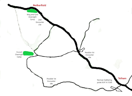


Key: Green shading   English Camps


Sketch 2


Above in Sketch 2 is my idea of how the English troops were arranged in the early morning of the 14th October 1066. 


Friday, 15 December 2023

Battle of Hastings - Pevensey to Hastings

 Pevensey to Hastings

I acknowledge the work done by John Grehan and Nick Austin  in doing some of the background work that has made my life and research easier. 

John Grehan/ Martin Mace  - Use of Ships to get from Pevensey to Hastings

Nick Austin - State of Selected Manors post October 1066

Use of Boat on Roman Fort

In my previous post we had got Wiliam to Pevensey and in this post I will take my narrative up to the the establishment of Hastings as a centre of operations.

Today Pevensey is some miles inland but back in 1066 the island of Pevensey was on the edge of "Pevensey Bay" and the island itself was just big enough for the Roman fort that was built there in the 400's plus a little bit. More historic information can be obtained on  https://www.westsussex.gov.uk/media/1740/pevensey_eus_report_maps.pdf

I'm not going to get into whether or not William stumbled when he waded ashore at Pevensey as the incident is immaterial in my view to the narrative. 

Most of our knowledge comes from the Bayeux Tapestry. Indeed, it details what went on at Pevensey over 6 scenes. 

Scene 39 

In this scene the horses are being shown as they are offloaded onto dry land. Notice that the horses are shown to be offloaded just the once. This ties into a local legend from Ninfield that the Normans landed nearby. What helps is that there is a channel of water that leads from what would have been Pevensey Bay, between Wartling and Hooe, to the south east of Boreham Street and north west of Hooe Common eventually arriving at Boreham Bridge (now called Waller's Haven). A couple of years ago a mass metal detecting exercise was held by Sussex Seekers along the edge of this stretch of water and copious amounts of nails were found. I'm hoping that some of these nails could be investigated further.** 

** I'm now investigating the possibility of the Normans dis-embarking at Ashburnham and that the nails represent burning ships floating down stream to Boreham Bridge and sinking there. Thus depositing nails at the site of sinking and not where they were set ablaze.

Scene 40 

The Tapestry now records that the knights raided Hastings for food. I think that there was a lot more going on for the knights other than "collecting" food. I'm sure that the knights would have gone to Hastings to secure William's landing place in the Harbour as well. This is where Nick's work with the manors comes in. He shows that all manors in the district were not pillaged equally (the ones furthest from Hastings were more lightly "touched").


Scene 41

This scene, for me, records the diligent work of the knights in securing food for William's army of infantry on Pevensey. 

Scene 42 

Two thirds of this scene is taken up with "domestic activity" i.e cooking. The last third shows the Roman fort after it had been "refurbished" by William's troops.. If you look closely you'll see that the roof consists of a boat turned upside down. Nick uses this to assert that a ship carrying a flat pack fort had foundered during the crossing at some point making the Normans use whatever to hand to improve the fort. I disagree with this thought. Much easier would be to use whatever was to hand to create a temporary shelter. 

Scenes 43 a and b

We're back to domestic activity in the Scenes. 

Scene 44 

This scene looks like a council of war is taking place between William, Odo and Robert. 

Scene 45 

This scene seems to be a transition scene between Pevensey and Hastings. Shown towards the right hand side of the scene is a part of a bailey on top of a hill with a tower placed at the bottom of the hill. Most historians equate the bailey that is shown with Hastings Castle perched on West Hill. Imo they're wrong. Hastings Castle extends to 20 metres above the current sea level at the mouth of what would have been a river outlet. Back in 1066 the sea level was about 19 metres higher and the deepest part of the inlet was adjacent to the bank that the castle was built on. We also know that the stone castle was built in the 1080's to prevent somebody doing a "William".  I can't remember where I read it but the Normans built fortifications at high points along any campaign route. To me, the Tapestry is saying that the Normans reverted to form and built a temporary motte and bailey between Hastings and what is now Battle. 

The Tapestry also shows a tower located at the bottom of the hill. Again most historians agree that this is another fort built by the Normans.But let us take a closer look it. 


My bad drawing of the "fort"

The cupola at the top of the building seems to indicate that this was a temporary building built by the Normans. However, on closer inspection the cupola and the inscription " HIC NUNTIATUM EST W are done in the same colour thread. This could be a later "improvement" or restoration in my view as without the cupola the item looks like the left hand half of a gable end. This changes the story for me to " The Normans requisitioned an existing building to use as a headquarters". I'm investigating the history of Trinity Mews in Hastings to see if it existed  in 1066 as the building is strategically situated to overlook both the ( now dry) inlet and the approach to the former inlet. 

 No comment is made about how the foot soldiers got from Pevensey to Hastings. The official narrative calls for the soldiers on Pevensey island to make their way to Hastings via Westham /Hailsham/ Herstmoncuex /  Ninfield and Crowhurst. John Greghan speculates that since the soldiers had to embark on their ships to get from Pevensey to the mainland why not just go direct to Hastings on board a ship that was going with the dominant wind?

What comes next? In my next blog I'll explore William's time in Hastings and the surrounds. 


Thursday, 7 December 2023

King and Conqueror - Initial blog setup

King and Conqueror - The continuing story of William and Harold 


Hi, 

This blog will be about the content of the television programme " King and Conqueror" not its participants. I'll let you decide whose acting is best/worst/indifferent, you don't need me for that. 

Let me introduce myself. I'm Kevin and I've been researching the Battle of Hastings for about 10 years. I'm a electronics engineer by training and education having walked the route from avionic repair technician to licensing of Satellite Ground Stations and other such duties in the Radiocommunications Agency. My interest in the battle of Hastings started when Nick Austin and John Grehan published books on alternative sites for the battle. Mix in my favourite Sunday night programme, Time Team and you've piqued my interest. So, starting with D.M Wilson's excellent book on the Bayeux Tapestry I started my own research. I have since acquired authoritative translations of the other three 11th century reports of the Battle ( EMC Van Houts, Davis and Chibnall and K Tyson). Now, my collection of 12th century reports is a bit mixed. While Orderic's missive and the Chronicle of Battle Abbey are authoritative translations ( Chibnall and Searle), The Chronicle of Henry of Huntingdon and Chronicle of the Kings of England by William of Malmesbury are translations made by reverends in the 19th century. The final two reports, Wace's Roman de Rou and Anglo-Saxon Chronicles, are translations by G.S. Burgess and M. Swanton respectively. 

I have a few contemporary books on the Battle which include R Allen Brown's book " The Norman Conquest of England" and "The Battle of Hastings" by Stephen Morillo. Let's finish with my least favourite author, Marc Morris and his book " The Norman Conquest".

I've also spent some time researching Edward, Harold's predecessor and his role in the story of England. So, for him, I scoured Frank Barlow's tome and that of Tom Licence. Also included in my quest for the man that was Edward, I delved into two books that don't get a mention in polite society, namely the puff piece written by St Ælred of Rievaulx and "The Life of St. Edward, King and Confessor" by R.F. Jerome Porter - another puff piece. 


King and Conqueror

I'm not holding out much hope for this series as this is what we read in the promotional material from the BBC :- 

King and Conqueror is the story of a clash that defined the future of a country – and a continent – for a thousand years, the roots of which stretch back decades and extend out through a pair of interconnected family dynasties, struggling for power across two countries and a raging sea. Harold of Wessex and William of Normandy were two men destined to meet at the Battle of Hastings in 1066; two allies with no design on the British throne, who found themselves forced by circumstance and personal obsession into a war for possession of its crown.

Nothing that I've read gives a hint that Harold and William were allies. The story as I understand it is :- 

Back in the day, Æthelred was concerned with Viking raids carrying off his population as slaves to be sold at market in Normandy. He was advised  to marry the offspring of Richard I, Duke of Normandy in the hope that he could persuade Richard to stop the Vikings selling English slaves.  Now Æthelred had five sons so any offspring from the union with Emma had little chance of progressing to the top job. Emma however, had two boys and a girl.  By the time Æthelred popped his clogs only two of the original sons were still alive ( Edmund and Eadwig). Edmund was considered unsuitable as King and Eadwig  was too. The job went to Canute, who outlawed Eadwig only to pardon him later ( only for Eadwig to be murdered!). In the meantime, after waiting for a year to pass, Emma married Canute and had another son, Harthacnut. The Danish interregnum lasted from 1016 to 1042 when it reverted back to "English" control. Even then it was meddling by Emma that caused it. She had Harthacnut declare Edward co-regent so that when Harthacnut died  ( unexpectedly!) Edward didn't have to face selection by the Witan to get the top job. 

Fast forward to 1051-ish, William visits his erstwhile cousin once removed ( Emma was his grandfather's sister) and goes away convinced he's been promised the throne. Now, it's time for the tin foil hat! In France at this time all titles were hereditary including the top job of King. So what convinced William he was in line for the English throne when a different procedure was used?  Using consanguinity from Roman times William was five whereas Eadgar was four but if it was determined by  the closest common ancestor then William was three as was Eadgar. Because of the contemporary records from the Anglo-Saxon Chronicles and and William of Jumièges, using words like underfang ( vassal - Marc Morris) and dominus ( Head of the Family) I suggest that Edward was not who he said he was and was Duke William's supposedly dead uncle William. 

The second mistake in the blurb from the BBC is "British" Such a simple mistake that any school child would be quick to correct. We are in fact talking about the English throne. The British throne wouldn't come into existence for another 600 years or so. 

So when King and Conqueror comes to Norway I'll give you chapter and verse on any deviations from the sources. You can make your own mind up as to whether the said deviances were plot holes or devices!


Tuesday, 28 November 2023

Battle of Hastings - The Crossing of the Channel

The Crossing of the Channel 

In my previous post entitled " the Departure form Dives", we left William and his army in St Valery sur Somme. 

William of Poitiers gives no details of the crossing other than three stops, one in the evening before dark, one after dark and one in the morning. 

William of Jumièges is even briefer, limiting himself  to saying that there was a favourable wind. 

The Bayeux Tapestry devotes just one scene ( Scene 38) to the crossing of the Channel

However, the Carmen devotes 25 lines to the Crossing ( lines 100 to 124). It can be interpreted as saying that there were two stops but with a bit more detail. The first stop is to form up into a fleet after leaving St Valery. In line 115 the Carmen records that an order was given to regroup entailing some ships to stop and drop anchor. In line 117 records that the stop lasted until daybreak. Finally they reach Pevensey at the third hour. 

I'm intrigued that the trip was done at night but thinking about it I realised that navigation would be easier than during the day. In line 97 the Carmen mentions the "pole Star" and in line 102 it mentions that the Moon was veiled and in line 110/111 we are told that each ship had own lantern tied to the mast. So the job of navigating devolved to one ship - William's. How did they navigate? Well, there seems to be some discussion as to whether or not the Normans had a simple compass or used the stars. I suppose it all depends on the brightness of the lantern tied to the mast. a very bright lantern would have obliterated any night vision but would have enabled watching a compass. 

The author of the Carmen wasn't a sailor as he intimates in line 107 that the Moon refused service. I don't think one can navigate by the Moon as it shifts the place where it rises almost on a daily basis. 

Of the 6 12th century sources I have ( I'm missing Roger of Worcester) only Wace has something interesting to say about the crossing of the Channel. In line 6535, Wace reports that a cleric with knowledge of astronomy presented himself to William. However, the cleric drowned on the crossing so William was not enamoured with the cleric's skills of prophecy. 

The Stray ship 

It would be remiss if I didn't address the stray ship that ended up in the Romney Marsh area of East Sussex. 

Now let's recap Williams journey from St Valery. All the ships leave harbour for the open sea but stop shortly after to form up into a fleet before striking out for England. In those couple of hours the fleet would have drifted southwestward and striking out at 315 deg would have had them on course for Beachy Head ( notable white cliffs near Eastbourne). As the fleet approached the coast, the remains of the Roman fort at Pevensey would have come into view on the starboard side of the ship. It would have been a small course correction to bring the fleet to the island. 

In the case of the stray ship it doesn't seem to have stopped after leaving St Valery and continued on a course of 315 deg until it reached the cliffs to the west of Hastings. These cliffs are not white but a light shade of brown. In order to reach the Romney Marsh are the captain would have needed to turn to starboard and look for a suitable inlet in which to moor. Can you see the similarities?


Monday, 23 October 2023

Battle of Hastings - Where did William land in the Port of Hastings?


 Where did William land at Hastings?

In this post I'd like to discuss where William landed at the port of Hastings. This is not about the knights leaving Hastings on the night prior to the battle but rather about where the foot of the Norman invader touched English mainland soil. To start, I'm going to use a page out of Hastings Historic Character Assessment Report April 2010. 

https://www.westsussex.gov.uk/media/1728/hastings_eus_report_maps.pdf

The above irl refers to a map of the underlying geology of Hastings Town centre. You will notice the extensive deposits of alluvium on what is now dry land ( alluvium is deposited by rivers?). At one point in time there must have been a large river emptying into the sea here thus making a good harbour.

Key: Green = land, Orange = water in the time of 1066, Blue = present day sea extent. 

Here's what I think the inlet would have looked like back in 1066. 

Now, the default wind direction is from the South west so any captain would have sought out a landing place on the western shore of an inlet subject to terrain. Also William had to move men and material from the shore inland to conquer it(!). 

We have no written accounts of where exactly William landed so all we have to go on is speculation. 

The present narrative calls for William to build a fort at Hastings which is remodelled in stone at a later date. So, the stone castle on the West Hill is thought to be the site of an early wooden fort built at the time of conquest. However, there is a problem with this thought. As any resident of Hastings knows, the land between say the present railway viaduct and Hastings Castle consists of a narrow strip of flat land backed by a very steep slope to the top of the ridge that ends with the castle.  I would imagine in geological terms that the river that flowed out here washed away the eastern bank.  Another thing to take account is the river bed when it went past the entrance to the inlet. 

                                           
                                              America Ground                                      Castle


Although this shows the modern ground level it echos what would have been the channel back in 1066. That is, the deepest part of the channel would have been closer to the castle. So in my opinion the castle was built there to protect the harbour from any seabourne invasion.

My theory is that William first touched English mainland soil in the vicinity of where Hastings Priory was built. Firstly, it is on the western edge of the inlet thus protected from the dominant wind. Secondly, it has the shortest route to the ridge behind Hastings without any undo elevation climbs. And thirdly, a Priory was built as a sort of "blue plaque" in honour of William and authorised between 1189 and 1199 ( reign of Richard the Lionheart). 


Sunday, 22 October 2023

Battle of Hastings - Cross section of the Main Battle Area


Cross Section of the Main Battle Area

In my last post I showed where I thought the main battle took place in 3D and what it looks like today courtesy of Google Earth. Today I bring you a cross section of the area to show Harold's battle planning. 

At zero on the "x axis"  is Wadhurst Lane where according to Wace the accompanying clergy of the Norman Army decanted to in order to watch the battle and pray. Looking at the slope now I think they might have been a little closer to the battle at the 80 metre mark say in order to see the debacle at the prepared defences. It is interesting to note that English Heritage when questioned about Wace's comment referred me to that Wace is describing a battle that happened in 1105 at Tinchebray but offered no supporting evidence.

I would also draw your attention to the fact that the Normans would have charged downhill towards the English line. I don't know if you have tried running downhill with abandon but it usually ends in a loss of control and crashing into something! In this case the Norman knights met with the defensive ditch as per Scene 53 of the Bayeux Tapestry


By Image on web site of Ulrich Harsh. - http://www.hs-augsburg.de/~harsch/Chronologia/Lspost11/Bayeux/bay_tama.html, Public Domain, https://commons.wikimedia.org/w/index.php?curid=17142223

The bottom of the slope is reached at approx 230 metres from Wadhurst Lane in what looks like a shallow ditch. Wace records in his work, Roman de Rou, that the English had made a ditch which ran through the fields. Now, it takes time to prepare defences like this. So, the earlier encounter the Normans had with the Huscarls must have been an attempt to slow down the invaders in order to give Harold's less able troops time to get things in place. Henry of Huntingdon has the Normans falling into a "deep trench" unawares due to the trenches being covered. In my reading of other modern reports on where folk think the battle happened, none have shown this ditch.

The ground now rises from the 260 metre mark to 320 metres from Wadhurst Lane.  How close the English were to the ditches is unknown but Harold, I would assume, would be at the peak of the ridge. This could explain why there is confusion over the "arrow in the eye" incident. The Norman archers could not closer than the 260 mark and thus Harold being higher in elevation and 60 metres away would be outside the killing range of a bow and arrow. It is interesting to note that the Bayeux Tapestry  show two members of the Fyrd exiting stage right with arrows in their eyes. 

Btw, I'm an electronics technician by training. This means I was trained to take on board all symptoms when trying to diagnose faults on a complex system, not just those which fit one's pre-determined idea. I've applied the same approach in trying to find the true battle site of Hastings. 


Battle of Hastings - The small battlefield?


My Chosen Battle Site for 14th Oct 1066
 
This site lies to the north west of Battle and as stated on the picture this represents the area where the main battle and Malfosse took place. 

The purple line represents where, according to Wace, the observing clergy stood praying and watching the battle. This also happens to be part of Wadhurst Lane, a restricted byway ( not for use for mechanically driven vehicles), which runs in part from the B2096 and Netherfield Road. It is high ground (109m - 111m) overlooking the the lowest levels of the English line. 

The turquoise ring represents where the English formed up to receive the Norman charge. The remaining portion of the English Army was here. Both the Carmen and Henry of Huntingdon indicate that the English were closely packed in their defensive line By my estimation there were 4500 English facing at least a comparable number of of Normans. Imo, this is what part of Scene 53  and Scene 54 of the Bayeux Tapestry attempts to show. 

  https://en.wikipedia.org/wiki/Bayeux_Tapestry_tituli#/media/File:BayeuxTapestryScene53.jpg
( From the drooping branch right)

https://en.wikipedia.org/wiki/Bayeux_Tapestry_tituli#/media/File:BayeuxTapestryScene54.jpg
( From the left to where the "mound" finishes)

All along the southeast facing part of the English line ( the part of the line that abuts the farmland) runs a shallow ditch. This could be the remnants of the ditches written about by Wace and Henry of Huntingdon. 

So Harold could possibly have died at the highest point on this ridge beside his Standard. 

Finally, the Malfosse could be where I've drawn an orange line. This represents a natural cleft near the battlefield as written about by the monks of Battle Abbey. Also the terrain within the wood from the battleline to the Malfosse conforms to the monks description of it. 

Anyway, what do you think?