The Narrative I Derive From the Bayeux Tapestry
Introduction
The
Bayeux Tapestry
This
embroidery, to give its proper English name, is reputed to have been made in
the south of England prior to 1080 which makes it one of the earliest records
of the events surrounding the battle and of the battle itself. If it was true
that it was commissioned in England, then this makes it the most complete
account from the English side. The Anglo-Saxon Chronicles written at that time
by monks seem to be more concerned with local matters with a smattering of
“national” news. The modern-day equivalent would be a bulletin of local radio news about the events in
a small English town with a ten second clip at the end of the news saying
something of national importance.
The
purpose of the Bayeux Tapestry, in my opinion, was to enlighten the lower
classes of the people of Normandy as to how their leaders had conquered the
English.
My
study of the Tapestry started at Scene 40 and went through to the end (Scene
58). However, I centred my attention on just to the left of centre on Scene 48
to the end of the Tapestry.
The
Bayeux Tapestry is not without its errors or possible additions.

Sketch 1
A
comparison of the same tower from Scene 46 one with a cupula as depicted on the
Tapestry and one without. Notice how the “tower” now looks like a gable end of
a building with a pitched roof. The stitching is done in the same coloured wool
for both the cupula and pitched roof suggesting the stitching was done at the
same time, the same coloured stitching extends into the lettering on the
tapestry to the top right of the object. The same coloured stitching stops at
the letter “W” in Willeim which suggests to me that the Tapestry was “improved”
and restored (pitched roof added) at a later date.
My Interpretation of the Bayeux Tapestry
My
interpretation of the Bayeux Tapestry starts on Scene 48 where it is thought
that picture shows the Norman knights setting off to meet the English. It ends on Scene 58 with the Fyrd running
away from the battle scene.
Scene 48 to Scene 49

Scene 48

Scene 49
This shows the Norman knights traversing fairly flat terrain finishing with a knight pointing, with raised arm, to the English.
There
are two things to note. One the writing above the figure believed to be William
in Scene 48 refers to the knights coming from Hastings (Here the knights have left Hastings and have come to the battle against King Harold)
but the sketch shows William with his equerry.
To me this means that William was in a different place than his knights,
bolstering Kathleen Tyson’s claim that William was at the manor belonging to Fécamp
Abbey the evening before the battle. Secondly, notice that the terrain that the
Normans cross is relatively flat before a final hurrah to get to Telham Hill. This does not match the terrain
between the coastal fort and the location of the muster point.

If the terrain is mapped out between Guestling and Telham Hill then the results that one gets is a path that fluctuates between 19 and 50 metres before rising to 130 metres at the muster point -just like the Tapestry is showing.
This includes part of Scene 49 and Scene 50.

Scene 49

Scene 50
This frame runs from Scene 49 to Scene 50 and depicts the Normans gathering at the muster point at Telham and pointing out the English while on the English side it depicts the Normans being spotted by the English and Harold being informed.
The last cameo in Scene 49 shows two Norman knights on the top of the hill between present day Battle and Hastings. It omits the hilltop fort which according to experts the Normans always built on their campaigns in France so one assumes that the muster point must have been a little closer to Battle than the fort. Given in the previous section the knights where moving along flat ground then the obvious way up from Kent Street would be the footpath that meets the A2100 at the Black Horse pub.
The next scene highlights the English response. The usual explanation of this scene is that this is the English “scouts” on Caldbec Hill spotting the Normans to the south and who then rushed off to tell Harold. Both Englishmen are depicted as Huscarls dressed in armour – hardly suitable attire for “scouts”. And yes, the designs on each of the shields are different so this could be indicating that these are different people.
The location of the Huscarls according to the present narrative is problematic.
If the Huscarls were camped on Caldbec Hill the
Normans on the hill opposite could have had a reason to use an alternative path
off the Hastings peninsula if the Huscarls were seen. If the Huscarls were on
Caldbec Hill and not seen then the Normans could have continued along the
present day A 2100 and the first encounter would have taken place at the
roundabout at the top of Battle High Street.
Regardless as to whether the Huscarls are seen or not, there is no need for the Huscarls to mount their horses in order to ride the 700 metres to the encounter as per Orderic Vitalis‘s account. Thus puncturing the present narrative.
If
the Huscarls were located at Beechdown Wood, then two possibilities exist for
the site of the first encounter.
1. Roundabout at the top of Battle High Street.
The Normans, knowing Harold was in the vicinity of
Netherfield, struck out along the modern A2100. The Huscarls then rode to the
roundabout from their overnight camp and gave battle.
2. 2. Area of flat ground to the
NE of Catsfield.
The Normans, seeing the Huscarls, struck out along the
alternative route towards Catsfield. The Huscarls then rode to meet the Normans
at what they thought was “a good spot” in a meadow called “Scan- leag”.
There is also a timing issue. The Sun would not be behind the Normans until after 08:00 if the Huscarls were situated on Caldbec Hill but from Beechdown Wood the Sun would be behind the Normans between 06:45 and 07:15 and low down necessitating the shielding of the eyes.
Event Bearing Sun Elevation Time
Huscarls on Caldbec Hill
Sunrise 106° 0° 06:26 GMT
Norman Muster point - 10° 127°
14° 08:13 GMT
Norman Muster Point 137°
19° 08:58 GMT
Norman Muster Point + 10° 147°
23° 09:38 GMT
Huscarls on Beechdown Wood
Sunrise 106°
0° 06:26 GMT
Norman Muster Point approx 111° 4° 06:57
GMT
Norman Muster Point + 10° approx 121° 10° 07:43 GMT
*
Data taken from https://www.timeanddate.com/ for Hastings UK 21
October 2019 (equates to 14 October 1066 Julien Calendar) and Google Earth. The
first engagement starts at approx. 09:00 GMT (Tierce).
Thus,
in my opinion, the narrative becomes “…. Lead
elements of King Harold’s Army had camped in Beechdown Wood for the evening of
the 13th and on the morning of the 14th October 1066 spotted the Norman Army on the
hill to the south east ...”
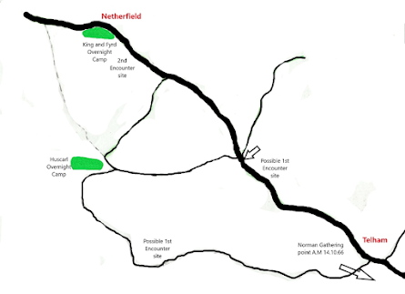
Key: Green shading English Camps
Sketch 2
Above
in Sketch 2 is my idea of how the English troops were arranged in the early
morning of the 14th October 1066.
No comments:
Post a Comment