Monday, 23 October 2023

Battle of Hastings - Where did William land in the Port of Hastings?


 Where did William land at Hastings?

In this post I'd like to discuss where William landed at the port of Hastings. This is not about the knights leaving Hastings on the night prior to the battle but rather about where the foot of the Norman invader touched English mainland soil. To start, I'm going to use a page out of Hastings Historic Character Assessment Report April 2010. 

https://www.westsussex.gov.uk/media/1728/hastings_eus_report_maps.pdf

The above irl refers to a map of the underlying geology of Hastings Town centre. You will notice the extensive deposits of alluvium on what is now dry land ( alluvium is deposited by rivers?). At one point in time there must have been a large river emptying into the sea here thus making a good harbour.

Key: Green = land, Orange = water in the time of 1066, Blue = present day sea extent. 

Here's what I think the inlet would have looked like back in 1066. 

Now, the default wind direction is from the South west so any captain would have sought out a landing place on the western shore of an inlet subject to terrain. Also William had to move men and material from the shore inland to conquer it(!). 

We have no written accounts of where exactly William landed so all we have to go on is speculation. 

The present narrative calls for William to build a fort at Hastings which is remodelled in stone at a later date. So, the stone castle on the West Hill is thought to be the site of an early wooden fort built at the time of conquest. However, there is a problem with this thought. As any resident of Hastings knows, the land between say the present railway viaduct and Hastings Castle consists of a narrow strip of flat land backed by a very steep slope to the top of the ridge that ends with the castle.  I would imagine in geological terms that the river that flowed out here washed away the eastern bank.  Another thing to take account is the river bed when it went past the entrance to the inlet. 

                                           
                                              America Ground                                      Castle


Although this shows the modern ground level it echos what would have been the channel back in 1066. That is, the deepest part of the channel would have been closer to the castle. So in my opinion the castle was built there to protect the harbour from any seabourne invasion.

My theory is that William first touched English mainland soil in the vicinity of where Hastings Priory was built. Firstly, it is on the western edge of the inlet thus protected from the dominant wind. Secondly, it has the shortest route to the ridge behind Hastings without any undo elevation climbs. And thirdly, a Priory was built as a sort of "blue plaque" in honour of William and authorised between 1189 and 1199 ( reign of Richard the Lionheart). 


Sunday, 22 October 2023

Battle of Hastings - Cross section of the Main Battle Area


Cross Section of the Main Battle Area

In my last post I showed where I thought the main battle took place in 3D and what it looks like today courtesy of Google Earth. Today I bring you a cross section of the area to show Harold's battle planning. 

At zero on the "x axis"  is Wadhurst Lane where according to Wace the accompanying clergy of the Norman Army decanted to in order to watch the battle and pray. Looking at the slope now I think they might have been a little closer to the battle at the 80 metre mark say in order to see the debacle at the prepared defences. It is interesting to note that English Heritage when questioned about Wace's comment referred me to that Wace is describing a battle that happened in 1105 at Tinchebray but offered no supporting evidence.

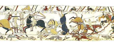
I would also draw your attention to the fact that the Normans would have charged downhill towards the English line. I don't know if you have tried running downhill with abandon but it usually ends in a loss of control and crashing into something! In this case the Norman knights met with the defensive ditch as per Scene 53 of the Bayeux Tapestry


By Image on web site of Ulrich Harsh. - http://www.hs-augsburg.de/~harsch/Chronologia/Lspost11/Bayeux/bay_tama.html, Public Domain, https://commons.wikimedia.org/w/index.php?curid=17142223

The bottom of the slope is reached at approx 230 metres from Wadhurst Lane in what looks like a shallow ditch. Wace records in his work, Roman de Rou, that the English had made a ditch which ran through the fields. Now, it takes time to prepare defences like this. So, the earlier encounter the Normans had with the Huscarls must have been an attempt to slow down the invaders in order to give Harold's less able troops time to get things in place. Henry of Huntingdon has the Normans falling into a "deep trench" unawares due to the trenches being covered. In my reading of other modern reports on where folk think the battle happened, none have shown this ditch.

The ground now rises from the 260 metre mark to 320 metres from Wadhurst Lane.  How close the English were to the ditches is unknown but Harold, I would assume, would be at the peak of the ridge. This could explain why there is confusion over the "arrow in the eye" incident. The Norman archers could not closer than the 260 mark and thus Harold being higher in elevation and 60 metres away would be outside the killing range of a bow and arrow. It is interesting to note that the Bayeux Tapestry  show two members of the Fyrd exiting stage right with arrows in their eyes. 

Btw, I'm an electronics technician by training. This means I was trained to take on board all symptoms when trying to diagnose faults on a complex system, not just those which fit one's pre-determined idea. I've applied the same approach in trying to find the true battle site of Hastings. 


Battle of Hastings - The small battlefield?


My Chosen Battle Site for 14th Oct 1066
 
This site lies to the north west of Battle and as stated on the picture this represents the area where the main battle and Malfosse took place. 

The purple line represents where, according to Wace, the observing clergy stood praying and watching the battle. This also happens to be part of Wadhurst Lane, a restricted byway ( not for use for mechanically driven vehicles), which runs in part from the B2096 and Netherfield Road. It is high ground (109m - 111m) overlooking the the lowest levels of the English line. 

The turquoise ring represents where the English formed up to receive the Norman charge. The remaining portion of the English Army was here. Both the Carmen and Henry of Huntingdon indicate that the English were closely packed in their defensive line By my estimation there were 4500 English facing at least a comparable number of of Normans. Imo, this is what part of Scene 53  and Scene 54 of the Bayeux Tapestry attempts to show. 

  https://en.wikipedia.org/wiki/Bayeux_Tapestry_tituli#/media/File:BayeuxTapestryScene53.jpg
( From the drooping branch right)

https://en.wikipedia.org/wiki/Bayeux_Tapestry_tituli#/media/File:BayeuxTapestryScene54.jpg
( From the left to where the "mound" finishes)

All along the southeast facing part of the English line ( the part of the line that abuts the farmland) runs a shallow ditch. This could be the remnants of the ditches written about by Wace and Henry of Huntingdon. 

So Harold could possibly have died at the highest point on this ridge beside his Standard. 

Finally, the Malfosse could be where I've drawn an orange line. This represents a natural cleft near the battlefield as written about by the monks of Battle Abbey. Also the terrain within the wood from the battleline to the Malfosse conforms to the monks description of it. 

Anyway, what do you think?